Baggao,  one of  the  28  municipalities  in  the province   of  Cagayan,   is  located   in   the eastern  part of Cagayan. It  is  bounded  on the north  by the  municipality  of  Gattaran,  on  the east by the mountain ranges of  the Sierra Madre Mountains  which  extend to  the  Philippine  Sea, on    the   southeast    by    the  municipality     of Peñablanca;    on    the     southwest     by     the municipality of Amulung and on the west by the municipality of Alcala, Cagayan.

Mission:

To uplift the general well-being of the people through the development of its agro-industrial and tourism potentials managed by an empowered and globally competitive community.

Vision:

Baggao an agro-industry-based, progressive and globally competitive municipality “known as Tourist Haven of the North driven by empowered, God-loving people living harmoniously with nature governed by service oriented leaders.

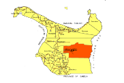
COORDINATES:    17* 55'N 121* 58'E
COUNTRY:          Philippines
REGION:             Cagayan Valley (Region 2)
PROVINCE:          Cagayan
DISTRICT:           1st District
BARANGAYS:       48
POPULATION:     82,171 (2013)
LAND AREA:        92,060 ha
INCOME CLASS:   1st Class
PRODUCTS:         Rice, Corn, Tobacco, Furniture


copyright 2012 ICT Office LGU-Baggao

All images appearing in this web site are the exclusive property of LGU-Baggao

The images may not be reproduced, copied, transmitted or manipulated without the written permission of ICT Office.

 
Make a Free Website with Yola.